Note the date Sunday 10th of October !
This is a bike ride with a difference. Cycle around the lovely country lanes of Kent, Surrey or Sussex. Solve the clues to help you navigate to find the checkpoints. Each checkpoint will involve a brain teasing challenge – a great day out for all!
For more details see this page Southern Cycle Saunter – Croydon Outdoor Pursuits & Social Events Club (copsecroydon.co.uk)
This event comes highly recommended by a reliable source (2 sources actually!) So how do I know?
It is a bit of a long story going back to several years ago. At that time I was in the Long Distance Walking Association, with my 2 sons and some other friends. We saw the Gatliff Marathon advertised by a Croydon based outdoor activity club. So we all signed up and did this 20+ mile, challenging hike on a winter’s day, across muddy fields and byways of Kent, Sussex and Surrey. And thoroughly enjoyed it!
Only several years later, did I meet our own Club member – Tim Styles – and even later still, I discovered that it was Tim who was the organiser of the Gatliff Marathon!
And another chance encounter.
In the last week of September I led a bike ride through Sevenoaks Weald on our way to a tea stop at Penshurst Place. Tim joined us on this ride and at the tea stop, Tim told us all about the Southern Cycle Saunter, which by coincidence, this year starts and finishes at Sevenoaks Weald!
The Saunter is organised by the same Croydon based activity club as Tim’s Gatliff Marathon. He and Sally have obviously been regular riders in previous Saunters! And what Tim and later, Sally, told me about the Saunter meant that this year I had to do it – and so do other Anerley cyclists!
So some more information about the event, for those who have read the details provided in the web page above, and might want to join us in teams of 4 riders – read on!
GETTING TO/FROM THE VENUE AT SEVENOAKS WEALD.
We need to be at the venue start point at the Weald Memorial Hall, by 9.30 to sign in, get route details, etc, before a 10.00 departure.
The organisers have asked if we can register our teams in advance of the day, as that will be very helpful to them. It will speed up checking in, etc, so riders can set off A.S A.P
By bike: The ride from Shurgard is 20 miles with several hills! So would take circa 90+ minutes. To be on the safe side I would suggest leaving from Shurgard at 7.30 on Sunday morning.
By car share: Two up with bikes on bike rack or inside cars, to reduce amount of parking space needed at the Weald. There is parking at the hall, venue for start/finish. But to be on the safe side get there early as I expect many other competitors will also go by car!

By train: There are 2 railway stations near by – Sevenoaks and Penshurst (the latter at Chiddingstone Causeway). I am advised by the event organisers of the following train routes and times.
“The rail routes are East Croydon to Penshurst via Redhill.
Depart East Croydon 08:27 arrives Penshurst 09:13 or depart East Croydon 08:49 arrives Penshurst 09:31.
It’s 4 miles from the station to Weald”.
( My note) I assume that the above details actually mean a train to Redhill, to connect to another train, for onwards journey to Penshurst Stn. I am not aware of a direct train from Croydon to Penshurst. Something for train users to check out. And let us all know!!!!
“Or Beckenham Junction to Sevenoaks.
Depart Beckenham Junction 08:42 direct to Sevenoaks arrives 09:19 or depart Beckenham Junction 08:50 via Orpington arrives Sevenoaks 09:29.
It’s 3.2 miles from the station to Weald.”
WHAT TO EXPECT AT THE EVENT!
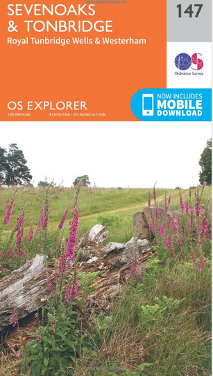
The event notes (see their web page above) state that each team should have an O.S Explorer Map No 147. Rather than buy one I went to my local library at Purley and got one on loan for 3 weeks. So try your local library!
I am also expecting to scrounge some from other sources – my son, a marathon walker, has one for another team’s use. And Tim has lent me another one. But do try to get one from your local library, to be on the safe side!
Note that Garmin or other Sat Nav aids are not to be used as they defeat the object of a map reading and related quiz. So no cheating – we are a sporting club!
Map reading!
When I joined Anerley B.C, every year we always held a map reading competition, similar to what can be expected on the Southern Saunter.
Using a map to navigate is not difficult and more about that below. Suffice to say, that quiz questions to solve, plus navigating with a map, is great fun – and exercises the old grey matter!
It will be advantageous for us to familiarise ourselves with the network of minor country lanes, within about a 7 mile radius of Sevenoaks Weald. For this purpose I will be leading Club rides during the next 10 days to do just that. I will also advise on things to look out for, and which might be the answers to map reference locations or other quiz questions.
Don’t forget to bring a pencil to jot down your answers on the sheets with the clues, provided by the marshals.
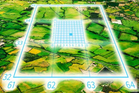
Map reading for this type of event, is principally about understanding and being able to use the grid system used on maps. Above is a diagram showing how maps divide an area into Grid Squares, using numbered Grid Lines. These numbers are used to provide a unique Grid Reference Number so that you can locate any place.
To explain this in some detail, see the article athttps://anerleybc.org/1/an-idiots-guide-to-map-reading/
I hope that following these instructions, will give you a start and some practise before the 10th October!
So that is all the latest information. If anything new comes in I will update those who have indicated an interest in doing this event – by signing up on the the Ride Register section that Vince has added to it.
Des