Maps and Navigation – The Unfolding Story.
With a hot summer on the far horizon, perhaps it is time to start planning your bike touring adventures. So something which follows on from a previous posting about map reading. There I explained how I started to learn our local geography by relating places and physical features to the various markings and symbols on a map. If you do this you will become familiar with working with maps. The next stage is navigation. This is the reverse of the first stage. Now you will be using maps to identify physical features on the ground to plot/follow a route. Which leads us to the query that prompted these notes about maps and navigation:
I just want to know how you know where to turn without getting the map out, unfolding and refolding while on the bike!
The answer is very simple. You can only go as far as your memory lets you! If you cannot remember the route you will have to stop and look at your map or other notes. On our normal club rides the leaders can only go along complex routes without reference to maps because, over time, they have learned the routes off by heart. When travelling further afield we do stop to unfold a map, check that we are where we ought to be, and memorise the next few miles.
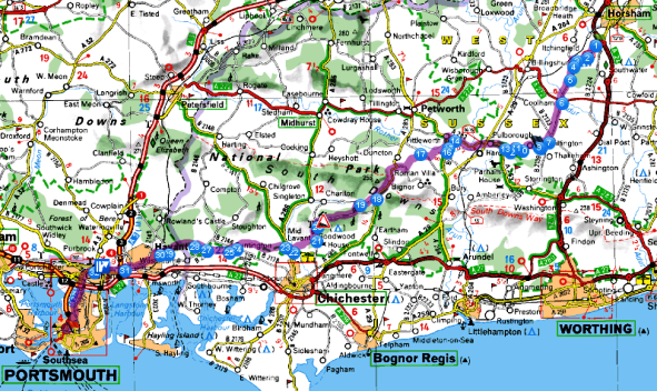
Let me use an example. I wanted to find the shortest route, avoiding main roads as much as possible, to Portsmouth to catch our ferry to Spain. I knew the way to Horsham, so from there, using the “Bike” option on Via Michelin, it produced this 60 + mile route. Much too far to memorise completely!

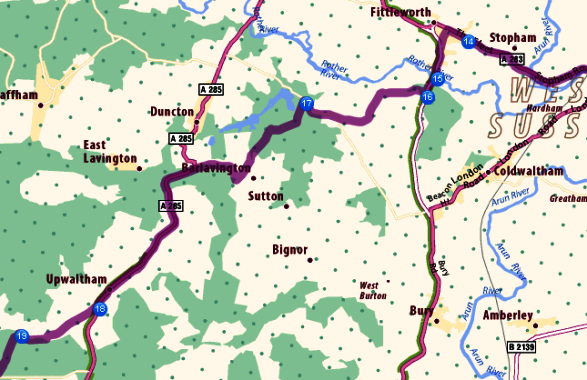
By enlarging the map scales to see more detail, I was able to confirm that this did indeed appear to be the best option for cycling. Below is a small section (from reference points 14 to 19) of the above map , but at a much larger scale. First I memorised the villages that we would pass thru, or near to. On this map section: Fittleworth, Barlavington, Upwaltham. These were place names to look out for on signposts when we cycled the route.
At even greater scales on screen, I could note road names, especially useful for where to do right/left turns into roads, where for example you can see road names. Road names are invaluable for navigating in built up areas, but in country lanes road names are often not signed.
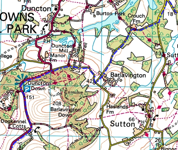
Taking the above map section and viewing it at even larger scale, I learned and remembered that I should take the A283 and take a left turn into School Lane as we entered Fittleworth, cross over the River Rother (no.15 on the above map) and the next right (no.16 on map) which takes us onto the O.S below. When we did the ride and came to this right turn it was a very minor lane with no road name or sign post. After checking the map we decided that it was indeed the correct place for the right turn.
Now have a look at the the OS map below. You can see how much better, and more useful, is the detail shown. Also, compared to the map above, you get a better idea of how the route zigzags in a generally south westerly direction.
When we did a recce on this route (see ride report), I managed the route from Billingshurst to no. 18 on the above map (by Crouch Farm on the OS map below) without any problems. However at this point we should have turned left, but I went straight on. As soon as I came to Burton Mill and its huge mill pond I realised that I had missed the turn. Only a minor problem as a small diversion took us back onto the correct route.
We stopped here at the mill for a short food/drink stop. There I checked the map and refreshed my memory for the next few miles. The detail of the OS map, with its closely packed contour lines and the view point symbol at Duncton Down, indicated a steep climb. We could see the hill from Burton Mill, so we knew we were on track.

We climbed the long steep hill, stopped at the view point for a brief rest, then continued to Upwaltham and then onto East Dean. A quick check of the map at East Dean where we needed to make a right turn, and then onto Goodwood and its famous race course.
And that is basically it. Memorise, using physical features, signposts, road names, etc, to jog the memory; continue as far as you are able to remember; check map, memorise, and continue to your next check point.
Much more fun and much more rewarding than relying on a GPS to guide you from A to B. A good map provides you with a picture of a large area, the terrain that you will be passing through, places of interest, and much more. And if you do get lost, which we all do at some time, it is not very long before, with the aid of a good map, you can find out where you are. But as with everything, practise makes perfect.
One last point. Above I have shown and referred to several different maps, all of which I studied on the internet. On the road I would use a map that is best suited to the ride, or which I might already have. I have shown some of my preferences in the earlier posting at http://anerleybc.org/maps-and-navigation-start-here/


